The short version
- European satellite data ranks Torfaen among the world's highest emitters of carbon per square kilometer due to July wildfires.
- Local authorities acknowledge elevated particulate matter but dispute the specific conclusions drawn from the EU assessment.
- Health advocates warn that prolonged smoke exposure poses significant risks to children and residents with respiratory conditions.
A series of intense wildfires in Torfaen, a county in south Wales, has resulted in carbon emission levels that rival some of the highest recorded globally per square kilometer. According to data released by the European Union’s Copernicus Atmosphere Monitoring Service, the region ranked behind only Malanje in Angola, Ávila in Spain, and Annaba in Algeria for wildfire-related emissions during July. This classification marks an extremely unusual environmental event for a temperate European locale, signaling a significant shift in regional climate patterns and their immediate consequences.
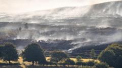
The primary source of these emissions was a major blaze on Mynydd Garnclochdy, situated between the towns of Abersychan and Blaenavon. Fire services described the incident as one of the most challenging in recent years for south Wales. The fire consumed approximately 80 hectares of common land and pasture, an area roughly equivalent to 300 football pitches. The scale of the operation was such that it triggered a major incident declaration, eventually requiring support from military personnel to assist local emergency responders.
The physical reach of the smoke extended far beyond the immediate burn zone. Residents reported detecting the scent of burning vegetation in Cardiff, located approximately 30 miles away. Local officials and community members noted that air quality deteriorated significantly during the peak of the fires. The visibility and odor of the smoke served as a stark indicator of the volume of particulate matter released into the atmosphere, affecting communities well outside the direct path of the flames.
Public health concerns have emerged regarding the potential long-term effects of this exposure. Save the Children Wales highlighted the specific vulnerability of young people, noting that children are breathing in smoke while coping with extreme heat and restricted outdoor activities. Melanie Simmonds, head of the organization’s Welsh branch, emphasized that developing lungs are particularly susceptible to damage from such conditions. The group warned that these environmental stressors carry serious health consequences that may not be immediately apparent but could manifest over time.
Local political representatives have echoed these health anxieties. Janet Jones, a councillor for Blaenavon, reported that smoke levels were particularly severe on August 13, roughly three weeks after the initial ignition. She expressed specific worry about the impact on elderly residents and individuals suffering from chronic respiratory issues such as emphysema and COPD. While she noted that local general practitioners had not yet reported a surge in respiratory complaints, Jones cautioned that this situation could evolve in the coming months as delayed health effects potentially emerge.
Despite the alarming data from European satellites, local government officials have expressed skepticism regarding the specific findings. Torfaen Council stated it was unaware of the EU data at the time of publication and questioned the evidence used to reach the conclusion that the county was a global hotspot. The council acknowledged that prolonged wildfires can adversely affect local air quality through increased smoke and particulate matter, but it argued that its own monitoring station in Croesyceiliog Cwmbran is designed to measure general background air quality rather than conditions immediately adjacent to fire sites.
The discrepancy between the satellite data and local monitoring highlights challenges in assessing environmental impact during rapid-onset disasters. The Copernicus program provides global information related to air pollution and health, offering a broad perspective that may capture peak emissions more accurately than ground-based stations located away from the epicenter. However, the council’s stance suggests uncertainty about how these high-level metrics translate to actual public health risks for specific neighborhoods within the county.
As the immediate emergency response winds down, attention is turning toward the longer-term implications of this event. The classification of Torfaen as a top global emitter for a single month underscores the increasing frequency and intensity of wildfires in regions not traditionally associated with such extremes. Whether this represents an isolated incident or part of a broader trend will depend on future climate data and local environmental monitoring. For now, residents remain vigilant about air quality, while health officials prepare for potential delayed impacts on vulnerable populations.
The incident also raises questions about preparedness for similar events in the future. The need for military assistance indicates that local resources were stretched to their limits by the scale of the fire. As climate change continues to alter weather patterns, regions like south Wales may face more frequent and severe wildfire seasons. Understanding the true extent of carbon emissions and health impacts from such events is crucial for developing effective mitigation strategies and protecting public health in the years ahead.
Sources behind this briefing
Go to the original reporting
- BBC Science & Environment↗Welsh county becomes global hotspot for carbon emissions after wildfires

