The short version
- A rare cloud-free satellite pass captured infrared evidence of a persistent lava lake at Mount Michael in the South Atlantic.
- Decades of thermal data from multiple instruments confirm low-intensity, continuous activity at this remote stratovolcano.
- The finding places Mount Michael among a select group of global volcanoes known for maintaining long-lived molten reservoirs.
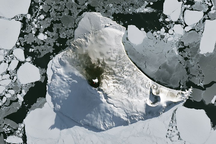
As the harsh austral winter begins to recede near the Antarctic Circle, a brief window of clear skies allowed satellites to capture detailed imagery of volcanic activity in the remote South Atlantic. This rare observational opportunity provided new visual confirmation of ongoing geological processes at Mount Michael, a stratovolcano located on Saunders Island. The clarity of the image, acquired in late August 2026, offered scientists a chance to examine features that are typically obscured by months of frozen darkness and heavy cloud cover.
The satellite data, collected by the Operational Land Imager on the Landsat 8 spacecraft, utilized infrared signals to reveal heat emanating from the volcano’s summit crater. This thermal signature indicates the presence of a persistent lava lake, a feature that distinguishes Mount Michael from most other volcanoes on Earth. The imagery also showed a volcanic plume hovering over the peak and darkened snow on the northern slopes, both of which suggest that the mountain remains geologically active despite its isolation.
Mount Michael is part of the South Sandwich Islands, a chain of small volcanic peaks formed by the subduction of the South American plate beneath the smaller South Sandwich plate. This tectonic interaction has led to regular eruptions across the archipelago in recent centuries. However, the extreme remoteness of these islands makes ground-based monitoring nearly impossible, forcing researchers to rely entirely on remote sensing technologies to understand their behavior and potential hazards.
The identification of a persistent lava lake at Mount Michael is the result of analyzing thermal anomalies from Landsat, Sentinel, and ASTER observations spanning three decades. This long-term dataset allowed scientists to conclude that the volcano hosts a frequently active molten reservoir. Such features are exceptionally rare globally; only a handful of other volcanoes, including Kīlauea in Hawaii, Nyamulagira in the Democratic Republic of Congo, and Erta Ale in Ethiopia, are known to maintain similar enduring lava lakes.
Beyond optical imagery, thermal observations from instruments like MODIS and VIIRS have enabled continuous monitoring of Mount Michael’s activity. Data processed through MIROVA, a near-real-time volcanic hot spot detection system, indicates that low-intensity activity has been ongoing at the volcano for several years. Additionally, observations from NASA’s Aura satellite show that emissions of sulfur dioxide and other gases are common occurrences at this site, further confirming its active status.
The weather patterns in this region remain volatile, and the clear view provided by Landsat 8 was short-lived. Within a week, clouds returned as Landsat 9 passed over the island, obscuring the volcanic features once again. However, the interaction between the atmosphere and the island’s topography created distinct visual phenomena. The 843-meter-high peak disturbed passing winds, producing wave clouds that resembled the wake of a ship, a familiar atmospheric effect in this part of the world.
False-color imagery from NASA’s Aqua satellite suggested that a volcanic track caused by degassing sulfur dioxide was likely present during this period of increased cloud cover. These atmospheric signatures provide additional evidence of the volcano’s ongoing emissions, even when direct visual confirmation of the lava lake is unavailable. The combination of thermal data and atmospheric tracking offers a comprehensive picture of Mount Michael’s activity.
The ability to monitor such remote volcanic systems is crucial for understanding global geological processes and assessing potential risks, even in areas with no human population. The persistent nature of Mount Michael’s lava lake provides valuable insights into the dynamics of subduction zone volcanism. As satellite technology continues to improve, scientists expect to gain even finer details about these isolated hotspots, enhancing our knowledge of Earth’s volatile interior.
This latest imagery serves as a reminder of the dynamic nature of the planet’s surface, even in its most inaccessible regions. The confirmation of Mount Michael’s persistent lava lake adds to the growing body of evidence regarding long-lived volcanic features. It underscores the importance of sustained satellite observation in tracking geological changes that occur far beyond the reach of traditional monitoring methods.
Future observations will depend on favorable weather conditions, which are unpredictable in the South Atlantic. However, the established baseline of activity at Mount Michael provides a solid foundation for interpreting future data. Researchers will continue to analyze thermal and atmospheric signals to detect any significant changes in the volcano’s behavior, ensuring that this remote sentinel remains under watch.
Sources behind this briefing
Go to the original reporting
- NASA↗A Bright Spot at Mount Michael

