The short version
- Hurricane Rachel has strengthened to Category 3 status off the coast of Baja California, bringing risks of landslides and flooding to Mexican states.
- Remnants of Hurricane Polo have caused record-breaking rainfall and widespread flooding across the U.S. Southwest and Midwest, disrupting transportation and power grids.
- Meteorologists attribute the unusually active Pacific hurricane season to El Niño conditions, which are creating warmer waters and favorable wind patterns for storm development.
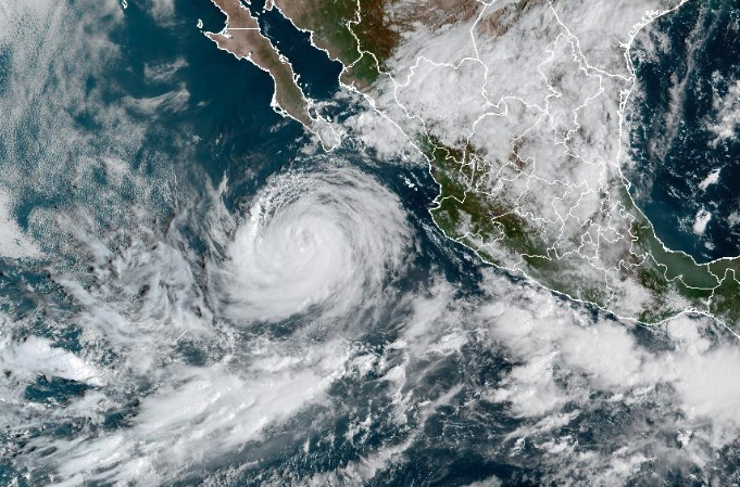
Hurricane Rachel has intensified into a Category 3 storm as it moves slowly west-northwest off the southern tip of Baja California. The National Hurricane Center reported maximum sustained winds of 120 miles per hour on Thursday evening, with forecasts indicating further strengthening before the system weakens later in the weekend. Located approximately 235 miles south of the coast, the storm is generating significant swells that are expected to create life-threatening surf and dangerous rip currents along Mexico’s Pacific shoreline.
Mexican authorities have maintained a state of alert for several regions, including Baja California Sur, Sinaloa, and Jalisco. Officials warn of very heavy rainfall that could trigger landslides, cause river levels to rise rapidly, and lead to flooding in low-lying areas. The U.S. Embassy in Mexico issued warnings for American citizens in Cabos San Lucas, advising them of beach and port closures due to the hazardous marine conditions.
This development occurs while northern Mexico and parts of the United States are still recovering from the devastation caused by Hurricane Polo earlier in the week. In the Mexican state of Sonora, hundreds of residents remain displaced or have lost their homes. At least 13 municipalities were still flooded as of Thursday night. Lucía Vegas, a resident of Bacabachi, described her family’s narrow escape from rising floodwaters that destroyed their home, noting they survived only because their dog alerted them to the danger in time to climb to the roof.
The impact of Polo’s remnants extends well into the United States, where heavy rains have battered states including Texas, Nebraska, Missouri, and Iowa. In Lincoln, Nebraska, Wednesday marked the wettest day on record with 6.1 inches of rainfall. Nearby Omaha received 4.7 inches, prompting the fire department to conduct 80 water rescues in a three-hour window as floodwaters reached depths of eight feet in some areas. Although schools remained open, many buses were stranded in flooded parking lots, forcing parents to transport students themselves.
In Texas, San Antonio remained under a flash-flood warning through Thursday evening, with officials urging residents to avoid unnecessary travel. Videos circulating on social media showed significant flooding along Interstate 35 in Denton. More than 19,000 residents across the state were without power on Thursday afternoon. The widespread nature of the storm system has also affected Chicago, where a wastewater utility urged residents to conserve water to prevent backups and flooding in the city’s drainage systems.
Kansas Governor Laura Kelly issued an emergency proclamation on Wednesday to allow state resources to assist first responders in communities hardest hit by the storms. This administrative action underscores the severity of the situation as multiple states deal with simultaneous infrastructure challenges and public safety concerns. The convergence of these weather events has strained emergency services and local governments across a broad geographic area.
Meteorologists attribute the unusually busy Pacific hurricane season to El Niño conditions. This climate phenomenon has fueled warmer ocean waters and specific wind patterns that serve as fuel for tropical cyclones. While El Niño has contributed to crippling droughts in parts of Mexico and Central America, it has simultaneously increased flood risks in other regions. Tropical Storm Nolo is also active in the Pacific, moving northwest away from Hawaii with potential to strengthen into a hurricane by the weekend.
As Hurricane Rachel continues its path, the focus remains on monitoring its trajectory and intensity changes. The National Hurricane Center expects the storm to weaken over the weekend, but the immediate threat of high surf and rip currents persists for coastal communities. Meanwhile, recovery efforts in areas affected by Polo’s remnants are ongoing, with many residents facing significant losses and disrupted daily life. The dual pressure of a new major hurricane and the lingering effects of previous storms highlights the volatile weather patterns currently affecting the region.
Sources behind this briefing
Go to the original reporting
- PBS NewsHour↗LIVE MAP: Track the path of Hurricane Rachel