The short version
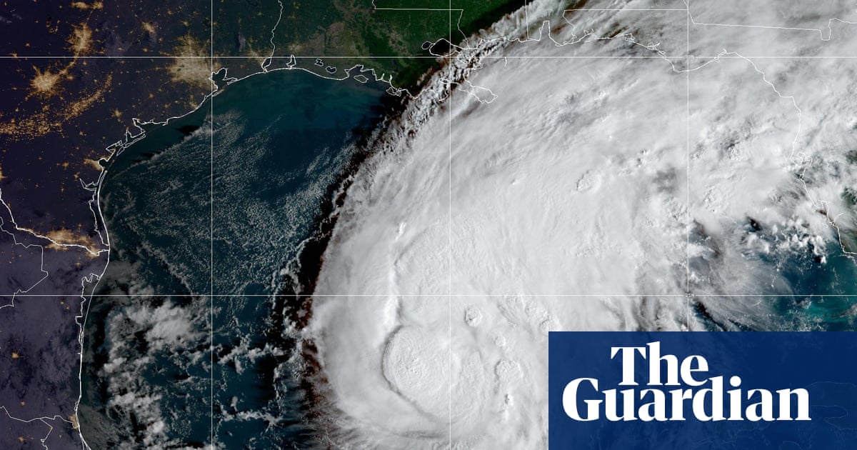
- Hurricane Isaias has strengthened into a Category 1 storm, marking the first hurricane of the 2026 Atlantic season as it moves toward the northern Gulf Coast.
- Governors in Alabama and Florida have declared states of emergency for dozens of counties, prompting school closures and mandatory evacuations in vulnerable coastal zones.
- National Weather Service officials warn of life-threatening storm surges, heavy rainfall, and potential tornadoes extending into Georgia and Tennessee through the weekend.
The 2026 Atlantic hurricane season has officially begun with a significant threat to the southern United States as Hurricane Isaias intensifies. After transitioning from a tropical storm late Wednesday, the system is now classified as a Category 1 hurricane with sustained winds reaching 80 miles per hour. Meteorologists project that the storm will pass north of the Yucatán peninsula on Thursday before turning its attention to the northern Gulf Coast. Landfall is anticipated between late Friday and early Saturday, positioning millions of residents in Louisiana, Mississippi, Alabama, and Florida directly in the path of potential severe weather.
Federal weather agencies have issued urgent warnings regarding the specific dangers posed by Isaias. The National Weather Service indicates that the storm is expected to strengthen further as it approaches land, potentially becoming a strong hurricane upon arrival. A primary concern for emergency officials is the risk of a life-threatening storm surge along portions of the northern Gulf coast. Consequently, storm surge warnings are currently active from the mouth of the Mississippi River extending eastward to Steinhatchee, Florida. Residents in these designated zones have been instructed to heed local guidance and evacuate immediately if ordered by authorities.
In addition to water-related hazards, high winds and precipitation remain major threats. Hurricane warnings cover a broad stretch from Ocean Springs, Mississippi, to the Bay/Gulf county line in Florida. Officials anticipate damaging hurricane-force winds across parts of the Florida Panhandle, southern Alabama, and southern Mississippi. These conditions are likely to cause long-duration power outages, disrupting infrastructure and daily life for extended periods. The National Weather Service has also highlighted the potential for heavy rainfall across the central Gulf coast and much of the Southeast from Friday through the weekend, raising concerns about flash flooding, urban inundation, and isolated river flooding.
The threat extends beyond wind and water to include tornado activity. Isolated tornadoes are possible on Friday night in coastal areas of Alabama, the Florida Panhandle, and far southwestern Georgia. This risk is expected to persist into Saturday for eastern Alabama, Georgia, and northern Florida. As the storm system moves inland, its remnants will continue to impact regions further north. The National Weather Service office in Morristown, Tennessee, has warned that heavy rain and strong gusty winds could affect the area this weekend, with high winds potentially exceeding 60 to 70 miles per hour in the eastern mountains and foothills.
State governments have moved quickly to mobilize resources and prepare for the incoming storm. Alabama Governor Kay Ivey declared a state of emergency for 40 counties on Wednesday, noting that this designation allows officials to take necessary preparatory steps ahead of landfall. The emergency order is scheduled to remain in effect until October 14. Similarly, Florida Governor Ron DeSantis issued a state of emergency declaration for 25 counties earlier in the week. DeSantis stated that the measure ensures communities have adequate time and resources to prepare for severe weather impacts affecting the Panhandle and Big Bend regions.
Local jurisdictions have also taken decisive action to protect residents. In Okaloosa County, Florida, officials declared a local state of emergency on Wednesday and ordered evacuations for some residents in coastal areas. Panama City issued its own emergency declaration due to the potential effects of Isaias on citizens and property within the city and surrounding communities. These local measures complement broader state efforts to manage the crisis. Several school districts across Alabama and Florida have announced closures ahead of the storm’s arrival, aiming to keep students safe during the period of highest risk.
Transportation networks are also bracing for disruption. The Federal Aviation Administration warned on Thursday that Isaias could lead to closures of Gulf routes, affecting air travel in the region. This potential disruption adds another layer of complexity to evacuation efforts and emergency response logistics. As the storm approaches, the combination of flight cancellations, road evacuations, and infrastructure vulnerabilities requires coordinated management from multiple agencies.
The situation remains fluid as meteorologists track the storm’s path and intensity. While current forecasts point to a late Friday or early Saturday landfall on the northern Gulf Coast, the exact timing and strength could shift. Residents in warning zones are urged to monitor official updates closely. The convergence of storm surge, high winds, heavy rain, and tornado risks creates a complex hazard profile that demands careful preparation. As Isaias moves closer, the focus shifts from forecasting to execution of emergency plans across the affected states.
The impact of this first hurricane of the season underscores the volatility of the 2026 Atlantic weather patterns. With millions under various levels of warning, the coming days will test the resilience of coastal communities and emergency management systems. The declarations of emergency by state and local leaders highlight the seriousness of the threat. As Isaias makes landfall, the immediate concerns will be minimizing loss of life and property through effective evacuation and response strategies.
Looking ahead, the aftermath of Isaias will likely involve significant recovery efforts. Flooding and wind damage may persist for days after the storm passes. The extension of tornado risks into Georgia and Tennessee suggests that the danger zone is broader than just the immediate coastline. Authorities in these inland areas must remain vigilant as the storm’s remnants bring heavy rain and gusty winds. The coming weekend will be critical for assessing damage and restoring essential services across the affected regions.
Sources behind this briefing
Go to the original reporting
- The Guardian World↗Hurricane Isaias forecast to bring dangerous storm surge, with millions under warnings in US