The short version
- Chiricahua is now the United States' 64th national park, ending a six-year gap since New River Gorge received similar status in 2020.
- The designation seeks to increase visitor numbers and support local economies while preserving a landscape shaped by ancient volcanic activity.
- The site serves as a critical ecological intersection for multiple biomes and hosts significant historical records spanning thousands of years.
Chiricahua National Monument in southeastern Arizona has been officially redesignated as Chiricahua National Park, marking the first new addition to the United States national park system in six years. This change brings the total count of national parks to 64, following the establishment of West Virginia’s New River Gorge National Park and Preserve in 2020. The transition from monument to park status is intended to elevate the profile of the site, which has been protected since 1924, by drawing greater national attention and potentially increasing visitor engagement.
Interior Secretary Doug Burgum characterized the landscape as one of the country’s most extraordinary environments during the announcement. He noted that the new designation would shine a spotlight on this previously lesser-known area, creating opportunities to welcome more visitors and strengthen local economies. Stakeholders including business owners, outdoor recreation groups, and political figures have expressed hope that the change will lead to a measurable rise in attendance. In 2025, the site recorded approximately 70,406 visitors, placing it at rank 254 among all National Park Service locations.
The park encompasses 12,000 acres within the Chiricahua Mountains, an isolated range rising from the deserts of southeastern Arizona and northern Mexico. These mountains are classified as sky islands, distinct ecosystems that stand apart from surrounding lowlands. The location sits at a unique ecological crossroads where four major systems converge: the Rocky Mountains, the Sierra Madre, the Sonoran Desert, and the Chihuahuan Desert. This convergence supports a diverse array of wildlife and plant life not typically found in such proximity elsewhere.
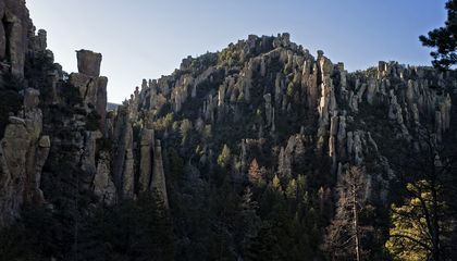
Geological forces shaped the park’s distinctive features over millions of years. Approximately 27 million years ago, a massive volcanic eruption covered the region in ash and debris. Over time, this material hardened into rhyolitic tuff, a rock layer that was subsequently eroded by wind, rain, and freezing temperatures. This erosion carved the landscape into a complex network of towering stone spires, balanced boulders, and narrow passageways. Conservationists describe the formations as mind-boggling in their complexity, offering visitors a sense of scale that dwarfs human presence.
Visitors can access these geological wonders through 17 miles of hiking trails, which allow for close observation of the rock structures. The experience is often described as immersive, providing a break from modern technology and the fast pace of contemporary life. Beyond hiking, the park offers scenic drives, stargazing opportunities, horseback riding, and camping. The surrounding Coronado National Forest, which covers 1.78 million acres, further enhances the recreational value of the area by providing additional wilderness space for exploration.
The biodiversity within the park is significant, supporting nearly 200 species of birds. These include both resident populations and migratory species traveling between North America and Central or South America. Mammals such as Coues deer, javelina, black bears, mountain lions, coatimundi, skunks, and 16 species of bats also inhabit the region. The area’s ecological richness makes it a destination for birdwatchers and wildlife enthusiasts who seek to observe animals in their natural habitats.
Human history in the Chiricahua region extends back at least 12,000 years. Paleoindians hunted big game in the area during early periods, followed by hunter-gatherer communities that utilized the diverse flora and fauna. Some groups eventually transitioned to agriculture. The Chiricahua Apache people lived across a vast territory including present-day southeastern Arizona, southwestern New Mexico, and northern Mexico. Their history in the region includes conflict with the U.S. government, culminating in forced removals during the late 19th century.
Later historical periods saw the presence of Buffalo Soldiers, homesteaders, immigrants, and Civilian Conservation Corps laborers in the area. Today, the park preserves these layers of history alongside its natural features. The name Chiricahua is believed to derive from an Opata word meaning wild turkey. As the site transitions to national park status, it aims to maintain its character as a place that has remained relatively unchanged over millennia, offering visitors a chance to connect with both the geological and human narratives of the American Southwest.
Sources behind this briefing
Go to the original reporting
- Smithsonian Magazine↗Arizona's Otherworldly 'Wonderland of Rocks' Is Now America's Newest National Park