The short version
- Tropical Storm Isaias is strengthening into a Category 2 hurricane, marking the first such storm of the unusually quiet 2026 Atlantic season.
- Forecasters project landfall between Louisiana and Florida late in the week, bringing risks of flooding, high winds, and coastal surge to residents.
- The storm’s development defies strong El Niño conditions that have suppressed hurricane formation for months, setting a new record for the latest start to hurricane activity.
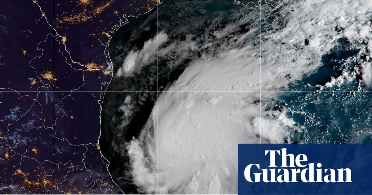
Tropical Storm Isaias has intensified into the first hurricane of the 2026 Atlantic season, breaking a prolonged period of inactivity that had set records for the latest onset of major storm systems. The system, which evolved from Tropical Depression Nine early Wednesday, is located in the warm waters off eastern Mexico and is expected to strengthen rapidly. National Hurricane Center officials project it will reach Category 2 status before making landfall on the United States Gulf Coast later this week.
The timing of this development is historically significant. The Atlantic basin had not seen a hurricane form this late in the calendar year since October 1905, and more recently, it set a new record for the latest date without a hurricane since satellite monitoring began in the 1960s. This quiet season has been largely attributed to a powerful El Niño event in the Pacific Ocean, which increases wind shear over the Atlantic and Caribbean, typically disrupting storm formation by tearing developing systems apart before they can gain strength.
Despite these suppressing atmospheric conditions, Isaias has managed to organize and intensify. The storm is currently moving east-northeast at approximately 8 mph with maximum sustained winds of 40 mph. It is positioned roughly 285 miles west of Progreso, Mexico, and about 580 miles southwest of the Mississippi River delta. Forecasters note that sea surface temperatures in the Gulf are running about 2 degrees Celsius above normal, providing the necessary thermal energy for the storm to grow even as broader seasonal trends suggest a lack of activity.
The precise path of Isaias remains uncertain, creating challenges for emergency preparedness. Initial models suggest the center of the storm could make landfall anywhere from eastern Louisiana to the western Florida Panhandle. There is particular ambiguity regarding when and where the system will execute its northeast turn toward the coast. Some projections indicate a potential landfall near the Alabama-Florida border early Saturday, while others point to Friday or Saturday morning for areas including Mississippi, Alabama, and Florida.
Residents along the northern Gulf Coast are being urged to prepare for dangerous impacts. The National Hurricane Center has highlighted increasing risks of damaging winds and storm surge. Forecasters anticipate that parts of Mexico, particularly around the Bay of Campeche and the Yucatan Peninsula, will experience the initial effects, including gusty winds and up to 4 inches of rain. As the storm moves northward, it is expected to bring torrential rainfall to the U.S. coast, with totals ranging from 3 to 6 inches across a broad area from southeastern Louisiana to northwestern Florida.
Localized flooding poses a significant threat, especially in urban environments where drainage systems may be overwhelmed. Some isolated areas could see up to 10 inches of rain, raising concerns about flash flooding and potential river overflow. In response to the growing threat, Florida Governor Ron DeSantis has declared a state of emergency across 25 counties in northern Florida. The National Weather Service is expected to issue hurricane and storm surge watches later Wednesday as the system continues its approach.
While Isaias is expected to weaken after moving inland and losing contact with warm ocean waters, it will still deliver disruptive weather to the southeastern United States. Rainfall of 1 to 3 inches is forecast for regions extending as far north as the Tennessee Valley and the Carolinas, with isolated totals reaching 5 inches. This marks a stark contrast to the previous year, when no hurricanes made landfall in the U.S., and follows Hurricane Milton’s impact in October 2024.
The broader context of this storm involves complex climate dynamics. The strong El Niño event is causing widespread weather disruptions globally, including extreme heat in temperate regions and severe flooding in places like Bangkok. While El Niño generally reduces the likelihood of Atlantic hurricanes by increasing vertical wind shear, it does not eliminate the possibility entirely. Isaias demonstrates that favorable local conditions, such as warm Gulf waters and temporarily low wind shear, can allow storms to develop even during historically quiet seasons.
Forecasters warn that wind shear is expected to increase dramatically in the 24 hours leading up to landfall, which may limit the storm’s maximum intensity. However, the exact trajectory and speed of Isaias remain subject to change as new data becomes available. Residents in the potential impact zone are advised to monitor official updates closely and ensure their hurricane plans are ready, given the unpredictable nature of late-season tropical systems.
This event underscores the variability inherent in hurricane forecasting, particularly when seasonal patterns deviate from historical norms. The combination of record-breaking delays and sudden intensification highlights the need for vigilance among coastal communities. As Isaias approaches, meteorologists will continue to refine their models, but the immediate priority remains public safety and preparedness for potential wind, rain, and surge impacts along the Gulf Coast.
Sources behind this briefing
Go to the original reporting
- The Guardian US↗Tropical Storm Isaias near Mexico is forecast to become a hurricane
- BBC Science & Environment↗Tropical Storm Isaias forecast to become first Atlantic hurricane of 2026