The short version
- Hurricane Polo is expected to become a major storm before turning away from the Mexican coast, bringing heavy rain and flood risks to Guerrero and Michoacán.
- Tropical Storm Odalys is strengthening in the Pacific and moving northwest, while Tropical Storm Fay weakens in the Atlantic Ocean.
- The current Atlantic season has seen no hurricanes so far, marking a record for the longest start without such storms due to El Niño conditions.
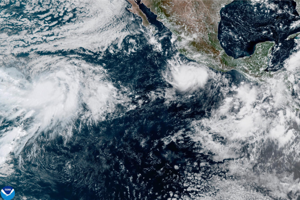
Hurricane Polo is undergoing rapid intensification in the Pacific Ocean and is projected to reach major hurricane status later this week. Meteorologists at the National Hurricane Center in Miami issued warnings on Monday regarding the storm's trajectory and strength, noting that it poses a significant weather threat to parts of Mexico. The system is currently moving eastward but is forecast to execute a sharp turn toward the west-northwest or northwest by late Tuesday. This shift in direction suggests the storm will travel parallel to the western coast of Mexico while remaining offshore, avoiding a direct landfall but still delivering hazardous conditions.
As of Monday, Polo was centered approximately 270 miles south-southeast of Manzanillo and 190 miles south-southwest of Zihuatanejo. The storm maintained maximum sustained winds of 80 mph at that time. Despite the offshore track, coastal regions are bracing for impacts starting late Tuesday and continuing into early Wednesday. Residents in these areas can expect rough surf conditions and tropical-storm-force winds. The proximity to populated coastal zones means that even without a direct hit, the peripheral effects of the hurricane will be substantial.
Precipitation forecasts indicate significant rainfall across coastal portions of the Mexican states of Guerrero and Michoacán through Thursday. Models predict between 4 and 8 inches of rain in these areas, with isolated totals potentially reaching near 12 inches. Such heavy precipitation raises concerns about localized flooding and mudslides, particularly in terrain prone to erosion or instability. Emergency management agencies are likely monitoring these risks closely as the storm system approaches the region.
Further west in the Pacific Ocean, another weather system is developing. Tropical Storm Odalys, located more than 1,400 miles west-southwest of the southern tip of Baja California, is expected to strengthen into a hurricane by midweek. On Monday, Odalys had maximum sustained winds of 45 mph and was moving northwest at 12 mph. Unlike Polo, Odalys remains far from land masses and does not currently pose an immediate threat to populated areas. Its development highlights the active nature of the Pacific basin during this period.
In contrast to the activity in the Pacific, the Atlantic Ocean has seen a notable lack of intense storm formation. Tropical Storm Fay is currently weakening, with top winds dropping to 50 mph as it moves southwest of the Azores. The broader context of the Atlantic season is marked by an absence of hurricanes so far this year. This trend has set a record for the longest start to a hurricane season without any named storms reaching hurricane strength.
Meteorologists attribute the subdued Atlantic activity to the influence of El Niño. This climate pattern tends to suppress storm formation in the Atlantic by increasing wind shear and altering atmospheric conditions that are necessary for hurricanes to develop and sustain themselves. The effects of El Niño have been evident in crushing potential storms before they can gain significant momentum, contributing to the historically quiet start to the season.
The divergence between Pacific and Atlantic activity underscores the complex dynamics of global weather patterns during El Niño years. While the Pacific sees rapid intensification and multiple tropical systems, the Atlantic remains relatively calm. This disparity requires distinct monitoring strategies for different regions, with coastal communities in Mexico preparing for immediate impacts from Polo while other areas observe the broader climatic trends.
Forecasters will continue to track Polo's path as it makes its turn away from the coast, ensuring that warnings are updated if the trajectory shifts closer to land. The potential for flooding and mudslides in Guerrero and Michoacán remains a primary concern for local authorities. Meanwhile, the development of Odalys and the continued weakening of Fay will be monitored as part of the overall seasonal outlook.
The situation illustrates the importance of staying informed about changing weather conditions, even when storms are not making direct landfall. Offshore hurricanes can still generate dangerous surf and high winds that affect coastal infrastructure and safety. As Polo moves through the Pacific, its evolution into a major hurricane will provide further data on how El Niño influences storm intensity in different ocean basins.
Residents in affected areas are advised to heed local guidance regarding flood risks and storm preparations. The combination of heavy rain and rough seas can lead to hazardous conditions even without direct wind impacts from the hurricane's core. As the week progresses, updates on Polo's position and strength will be critical for assessing ongoing threats to coastal communities in Mexico.
Sources behind this briefing
Go to the original reporting
- PBS NewsHour↗Polo has rapidly intensified to a hurricane and is expected to impact Mexico