The short version
- At least 47 fatalities have been confirmed following a powerful magnitude 7.7 earthquake that struck eastern Indonesia early Saturday, with officials warning the death toll is likely to increase.
- Although a broad tsunami warning was issued and later lifted, monitoring stations recorded significant wave heights in several coastal villages, causing mud deposition and infrastructure damage.
- Rescue operations are severely hampered by landslides blocking major highways, communication blackouts, and the remote, mountainous terrain of the affected regencies.
A powerful magnitude 7.7 earthquake struck off the coast of Indonesia early Saturday, killing at least 47 people and causing widespread destruction in a region already vulnerable to seismic activity. The tremor hit eastern Indonesia’s Flores region at a shallow depth, intensifying its destructive potential on the surface. Authorities have confirmed that dozens more residents were injured, and officials warn that the final death toll will almost certainly rise as search and rescue teams gain access to isolated areas.
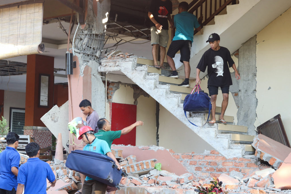
The National Disaster Management Agency reported that the quake flattened at least 157 homes and damaged nearly 200 others, forcing approximately 2,000 villagers to abandon their residences. Beyond residential structures, more than 100 public facilities were destroyed or severely compromised, including schools, medical centers, and churches. In Sikka, Manggarai, and East Manggarai regencies, the damage was particularly severe, with many buildings collapsing entirely.
Shortly after the initial shock, authorities issued a tsunami warning, prompting residents along the coast to flee to higher ground. Videos from the port in Maumere showed chaos as parts of the terminal building collapsed onto waiting passengers. While the broader tsunami alert was lifted after three hours due to a lack of significant sea-level changes threatening major coastal communities, localized waves did impact several villages.
Monitoring stations recorded tsunami waves reaching heights of 1.61 meters in the coastal village of Riung, leaving behind thick layers of mud and debris that stranded fishing boats and damaged local infrastructure. Smaller but notable waves were also observed in Maurole, Bulukumba, and Sape. These localized surges contributed to the panic among residents, many of whom remained outdoors or in temporary shelters due to fear of aftershocks.
Rescue efforts have been significantly complicated by logistical challenges inherent to the geography of East Nusa Tenggara. The province consists of numerous islands and rugged terrain, making access difficult even under normal conditions. Following the earthquake, landslides triggered by the shaking blocked the Trans-Flores highway, a critical 700-kilometer road spanning Flores Island. This disruption has cut off several remote villages, some of which are reported to be completely buried under debris.
Communication networks in the affected areas have also suffered outages, hindering the coordination of emergency response teams. Police officials noted that these disruptions made it difficult to gather accurate reports on casualties and damage levels in real time. To mitigate these issues, authorities deployed three helicopters and a rescue vessel to support logistics, transport supplies, and facilitate potential evacuations from hard-to-reach locations.
The human toll of the disaster is evident in accounts from survivors who described the terror of the event. Residents reported being awakened by intense shaking that felt unprecedented in their experience. In one instance, students at a seminary fled an assembly hall as its roof collapsed during morning services. One priest suffered a broken leg while jumping from a second-floor window to escape the falling structure. Many others chose to sleep outside or cook outdoors for fear of further tremors.
In addition to the primary quake, the region has experienced hundreds of aftershocks, with the largest recorded at magnitude 6.2. Later on Saturday, another significant earthquake struck North Sumatra in western Indonesia. However, this second event occurred at a depth of over 170 kilometers, meaning it was too deep to cause substantial surface damage or casualties. As assessments continue, aid organizations are focusing on delivering supplies to the most affected areas while navigating the ongoing risks posed by unstable structures and potential further seismic activity.
Sources behind this briefing
Go to the original reporting
- PBS NewsHour↗Magnitude 7.7 earthquake strikes off Indonesia's coast, killing at least 47 and toppling buildings
- BBC World↗Powerful magnitude 7.7 earthquake kills at least 47 in Indonesia